On a crisp September morning in 1935, a group of men hired off relief rolls stood at a gap in the hills near the Virginia line, staring at a tangle of steam shovels and dump trucks. They were supposed to break ground on a road that would one day stretch 469 miles across the crest of the Blue Ridge Mountains. But the machines weren’t ready. The ground wasn’t ready. And the mountain, as they would learn, was never going to make it easy.
That first delay—eight days late on the very first job—was a sign of everything to come. The Blue Ridge Parkway would take 52 years to finish, cost far more than anyone imagined, and require engineers to solve problems no road builder had ever faced. It would survive a hurricane, a world war, and a 13-year standoff over a single mountain. And when it was finally done, it would be closed again—all 469 miles of it—by a storm that reminded everyone who really holds the power in these mountains.
In December 1933, a young landscape architect named Stanley Abbott, just three years out of Cornell, was handed a blank map of the Southern Mountains and told to design a road nobody had ever built. His instructions were the opposite of what highway engineers of the time were trained to do. Instead of cutting through ridges and filling hollows to keep the line straight and fast, Abbott was told to fit the road into the mountains so it looked like it belonged there—as if it had always been part of them.
“Follow the crease and you hardly see the stitches,” as one historian put it. “Cross it and you leave a scar.” Abbott wanted the stitches to follow the crease for more than 400 miles.
But first, someone had to decide where the crease even was. A North Carolina highway engineer named R. Getty Browning walked the ridge lines mile after mile in 1934, notebook in hand, picking out the line that would hold the views. Tennessee wanted the southern half of the road on its side of the mountains. A federal committee agreed with Tennessee. Then, on November 10, 1934, Secretary of the Interior Harold Ickes overruled his own committee and gave the line Browning had walked to North Carolina. That decision is why the Parkway spends most of its miles in North Carolina and why it climbs so high there.
The ridge Browning picked so carefully was the same ridge that would fight the builders hardest.
They attacked it by breaking the road into pieces—45 separate construction units, each with its own contract, crews, and start date. Part of that was because the land came in slowly, farm by farm. Part of it was deliberate: 45 jobs meant crews could work in many places at once, and in 1935, that meant more people with a paycheck.
On June 30, 1936, Congress made it official, gave the road its name—the Blue Ridge Parkway—and put it in the hands of the National Park Service. The budget for the entire road was $16 million. Hold on to that number. It would look very small by the end of the story.
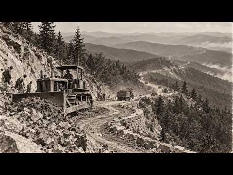
The road went to contractors with steam shovels and dump trucks, to crews from the Works Progress Administration, and to four camps of the Civilian Conservation Corps where young men did roadside cleanup, planting, and the grading of slopes so the raw cuts would heal into the hillsides. On most highways of the time, when you blasted a cut through a ridge, you left the scar. On the Parkway, the cut banks were rounded off and planted so they would look like the mountain had settled that way on its own. The guard walls, culverts, and bridges were faced with stone taken from the ground right there, laid by masons so the stone matched the rock it was cut from.
A road that looked effortless was costing extra effort at every single bend. And Abbott was the man responsible for all of it. In March 1937, still in his 20s, he was named resident landscape architect and acting superintendent of the entire Parkway. He was in charge of a road that existed mostly on paper—and the mountains had not yet shown him what a really bad day looked like.
The problem with building a road along the top of a ridge is simple: on a valley road, the water is below you. It runs off the pavement into a ditch and down to the river, and the river carries it away. Up on a crest, the road sits across the slope. Every bit of rain that falls on the mountain above it comes downhill, hits the road, and has to go somewhere. If it can’t get under the road, it goes across it. And if it goes across it often enough, it takes the road with it.
Picture what a single mile of that took in 1936. The surveyors staked the line along the slope. Then a steam shovel bit into the uphill side and swung the rock and dirt across to the downhill side so the road would sit on a shelf that was half cut into the mountain and half built out from it. Where the slope was solid rock, the crews drilled and blasted first, and the shovel came in behind them. The fill had to be packed in layers or it would slump the first time it got wet. And every bit of it was done on a grade where a dump truck that lost its brakes had nowhere to go but down.
It’s like carving a step into the side of a sand dune and then trying to stand on it. The step is only as good as the sand under the half you added.
So for every mile of pavement, the crews also had to build a hidden second road for water—culverts under the grade, ditches on the uphill side, stone-lined outlets on the downhill side, so the water would leave without carving the slope away. Most of it you never see when you drive the Parkway today. But it was some of the hardest work on the whole job, because a road on a mountainside lives or dies by where its water goes.
And on the first sections, the water didn’t always go where it was meant to. On some stretches, drainage that hadn’t been laid quite right was already cutting gullies along the new road. In a normal summer, that’s a maintenance job. A crew comes out with shovels and a few loads of rock.
By the summer of 1940, the Parkway was taking shape in pieces up and down the ridge. Stretches were open and carrying cars in Virginia and in North Carolina, and others were graded and waiting for their surface. Tourists were already pulling over at the new overlooks to look out over the hollows.
The weather that August didn’t look like anything special at first. A tropical storm had come ashore on the Atlantic coast and was dying as it moved inland the way storms usually do. But this one stalled over the mountains of western North Carolina and stayed there.
On the evening of August 13, 1940, in the mountain town of Boone, the rain gauge recorded two inches between 5 and 6 p.m. In one hour. And it didn’t stop.
Over the next 48 hours, the area around Boone took about eight inches. At a place called Idlewild, the gauge caught more than 20. The ground on those mountain slopes was thin soil over rock, and once it was full of water, it simply let go. In Watauga County alone, the storm set off more than 2,000 landslides. Sixteen people in that county died. Across the region, the count reached about 50. Bridges went out on nearly every road into Boone. The telephone lines went down and the town was cut off from the outside world for days. The little railroad that had served Boone never ran there again.
And up on the ridge, the new Parkway was caught right in the middle of it.
The Park Service sent a photographer out the moment anyone could move. On August 16, 1940, the camera stopped at milepost 320 in a construction section the engineers called 2K, where a whole piece of the mountain had slid down across the new road. The next day, a man named Asa Burns was out photographing the damage from milepost 237 to milepost 248. Fallen trees, washed-out shoulders, and slides one after another across the roadway.
Those photographs still exist, and what they show is a road that had done exactly what Abbott designed it to do—laid gently along the slope, now with the slope coming down on top of it. That’s the cruel part of building along a ridge. The road is in the one place where the whole mountain’s water and soil have to cross it. In a storm like that one, there is no place on the hillside a road can hide.
So the crews went back to the drainage. Slides were cleared, slopes were rebuilt, and the lesson of those gullies went into every section that came after it. The Parkway that survived 1940 was built to move water harder than the one before it.
But the next thing to stop the road wasn’t water. It was a world war.
When the United States entered the Second World War, the Blue Ridge Parkway was about a third of the way to being a real road and two-thirds of the way to being a promise. Roughly 170 miles were open to travel, and about 160 more sat graded, half-graded, or waiting on bridges. Then the money went to the war, and the men went with it.
By 1943, construction had come to a halt for the duration. For 160 miles, raw cuts sat unplanted, fills settled, and drainage ditches went uncleared, all exposed to mountain weather with nobody to defend them. Then came a crew nobody expected: conscientious objectors—Mennonites, Brethren, and Quakers—who had refused to fight and were sent to keep the mountain from taking back what already existed. They couldn’t build the road, but they could hold the line.
When the war ended, the builders came back slowly. New machinery was scarce, and by the early 1950s only about half the Parkway was finished. What saved the schedule was Mission 66, a ten-year push to finish by 1966. The easy sections had gone first; what remained lay in the high country, where ridges break into a tangle of separate ranges.
The Parkway has 26 tunnels, 25 of them in North Carolina, most bored in the late 1940s and 1950s. Drillers rode a rig called a jumbo, drilling patterns of holes, packing them with dynamite, and mucking out the broken rock. On a good stretch, a crew might gain about ten feet a day—the length of a small car, with the whole mountain sitting on top of you.
By the end of 1966, everything was done except 7.7 miles on the side of one mountain in Avery County. That mountain belonged to Hugh Morton, who had built a toll road and the Mile High Swinging Bridge. He fought the high route for 13 years, warning that a road cut across his mountain would be “like taking a switchblade to the Mona Lisa.” Finally, in the late 1960s, a compromise line was accepted—and it ran straight across Lin Cove, the worst ground on the entire mountain.
Lin Cove was a steep slope piled with huge loose boulders. You couldn’t cut it, couldn’t fill it, couldn’t haul machinery across it. In 1975, engineers drilled into the boulder field and concluded there was no way to build an ordinary road across it at all. So the road would never touch it. The answer was a viaduct—a bridge running along the slope instead of across a river, built entirely from the top.
At the south end, a casting yard produced 153 hollow concrete segments, each about 50 tons, and because the bridge curved and banked in an S, almost every one was a slightly different shape. Out of 153 segments, only one—number 93—is straight and square. A stiff-legged crane sat on the finished deck and swung each new piece out over the void. Epoxy glue coated the joint, steel tendons running through the boxes were pulled tight, and the new segment became one piece of concrete with the old.
It was like building a diving board out over a pool, one plank at a time, while standing on the end of the board. Seven piers, spaced about 180 feet apart, held up the reaching end. Their foundations rested on micro-shaft piles drilled through the boulders into solid rock—the only work done on the ground in the whole job. Rex Kokraftoft, the federal supervising engineer, watched every segment go out, knowing that once it was glued and pulled tight, it was the bridge.
Construction started in 1979. The final cost was about $9.8 million for a little over a quarter mile of road—well over half the original $16 million budget for all 469 miles. The viaduct was completed without a single structural problem. Not one crack. But the Parkway still wasn’t open. For another four years, the most famous bridge on the road sat finished and empty while drivers kept getting sent around the mountain on US 221.
They chose the date on purpose. On Friday, September 11, 1987—exactly 52 years to the day after the men from the relief rolls started unloading machinery at Low Gap—the missing link opened to traffic. The road that began eight days late on its first job closed its last gap right on the anniversary. The men who dragged those first steam shovels into place could have been the grandparents of the drivers who rolled across Lin Cove that September.
But a road on a mountain is never really finished. The mountain still has the last word. And 37 years later, it used it.
In late September 2024, Hurricane Helene came ashore in Florida as a category 4 storm and drove north into the southern Appalachians. In parts of the Blue Ridge, it dropped as much as 30 inches of rain. The ground did what it had done in 1940, only bigger. Along the Parkway, the Park Service counted 58 catastrophic landslides. Whole sections were undercut and slid away, and at least one old tunnel was damaged.
For the first time in its history, 100% of the Blue Ridge Parkway was closed. All 469 miles, the road that took 52 years to connect, was shut in a matter of days.
The worst of it landed from Linville Falls south toward Mount Mitchell—the high country just south of Grandfather Mountain, the hardest ground on the whole route. Near Linville Falls alone, in a stretch of about 38 miles, the Park Service documented more than four dozen landslides, some stacked on top of each other. Rachel Stazzy, the Parkway’s acting superintendent, put it plainly: “Some of the slides are actually inaccessible until you fix other slides. You have to fix them sequentially.”
That’s the old problem of the ridge again. On a road along a crest, there’s no detour for the trucks. To reach the slide at the far end, you have to rebuild the road through the slide in front of it first. The way they’re rebuilding many of those slopes is called a reinforced soil slope—a tiered cake of gravel and wire mesh. Dig out the failed ground, build the slope back up in layers of stone wrapped and tied in wire, cover it with topsoil, plant it, and lay the road back across the top. It’s the drainage lesson of 1940, built in steel this time.
One repair zone runs from milepost 318.2 to 323—the very spot where a Park Service photographer found a slide across the brand-new road on August 16, 1940. Eighty-four years apart, the mountain came down on that same stretch of road.
On October 11, 2024, the first sections began to reopen. In its first year of recovery, the Park Service counted 350,000 cubic feet of debris hauled off the road and more than 22,600 hours given by volunteers who came to help put their road back. By the fall of 2025, more than 400 miles were open again. The last of the worst-hit miles are scheduled to be finished by the end of 2026—which means that right now, the Blue Ridge Parkway is being built again.
So go back to that photograph from the beginning. The crane leaning out over Lin Cove, the curve of concrete still open at one end, and the few small men in hard hats standing on the edge of it. What they were standing on was the road itself. Fifty-two years after the first steam shovel, the last piece of the Blue Ridge Parkway was built by standing on the end of it and reaching out over a mountain nobody would let them cut.
And the boulders are still down there today, exactly where the mountain left them.
If you could stand at the edge of that unfinished bridge in 1983, with nothing but air and boulders below, would you have trusted the engineers enough to walk out onto the next segment—or would you have waited for the mountain to have the final word?
Report this article
Select a reason for reporting: