On May 20, 2017, a mountainside at Mud Creek on the Big Sur coast let go. More than six million cubic yards of rock and dirt buried a quarter-mile of Highway 1 and pushed fifteen acres of brand-new land into the Pacific. Nobody was hurt—because the crews had been pulled off the slope that same day. The mountain waited until they were gone.
That road was blasted into those cliffs a century ago by convicts and dynamite over eighteen years. The mountain has been trying to throw it back into the sea ever since. I wanted to know how anyone cut a road into a coast like that—and how it is still there at all.
Two people carry this story. The first is a country doctor named John Roberts, who once needed nearly four hours on horseback to reach a shipwreck at Point Sur and decided the coast needed a road. The second is Ernest Pierce, an equipment operator from Morro Bay that everybody called Skinner, who went to work on that road one spring day in 1983 and did not come home.
Between them, the road had to beat five enemies in this order: a wall of granite with no shore under it, an empty bank account, a canyon 260 feet deep, the storms, and last, the mountain itself, which never stopped moving.
The first enemy was waiting for Roberts the day he tried to answer a call for help. Roberts had founded the town of Seaside near Monterey in 1887. He was the town’s planner, its postmaster, and its doctor, and he visited his patients on horseback. In 1894, a steamer called the Los Angeles went onto the rocks near Point Sur and Roberts was sent for.
Point Sur is not far from Monterey on a map. On horseback, it took him nearly four hours. There was no road along the water because along most of that coast, there is no place to put one. The Santa Lucia mountains do not slope down to the sea. They drop into it.
That is the strange arithmetic of Big Sur. The shortest route between Carmel and San Simeon is the one along the ocean. And for a hundred years, it was the one route nobody could use. The wagon road that did exist ran inland behind the ridges. Where it met Bixby Creek, a few miles south of Carmel, it swung eleven miles away from the coast just to get around one canyon. A trip that should have taken an afternoon could take three days.
So in 1897, Roberts went to see the coast on foot. He took a Monterey attorney named Frank Powers with him. The two men walked the rocky coastline south towards San Simeon for five days. Roberts sketched the route and kept notes. Powers carried a stereopticon camera—the kind that takes two pictures side by side, so the scene jumps out in three dimensions—and he photographed the cliffs they would have to cut through.
When they reached San Simeon, they did not walk back. They went home by ship. I like that detail more than I should. The two men who had just mapped the first road down the Big Sur coast finished the trip the way everybody on that coast had always traveled: by water, because there was no other way.
Roberts spent the next eighteen years carrying that survey around. In 1915, he finally stood in front of a joint session of the California legislature and showed them his notes and the photographs. He had a road on paper. What he didn’t have was anybody willing to pay for it.
The money came from a man who had grown up at the south end of the route. Elmer Rigdon was born in Cambria just below San Simeon in 1868. He was a rancher who also ran timber, a brickyard, and a quicksilver mine before he went into politics. By the time of the First World War, he was a state senator sitting on the Senate Committee on Roads and Highways.
Rigdon had his own reason for wanting the road, and he had an argument the legislature could not ignore. California’s coast, he said, could not be defended without it. A shoreline with no road was a shoreline nobody could reach in a hurry. In 1919, the legislature put a bond measure in front of the voters. $1.5 million for a highway from Carmel to San Simeon. The voters said yes.
Eighteen years of work began there, and most of the people who started it would not see it finished.
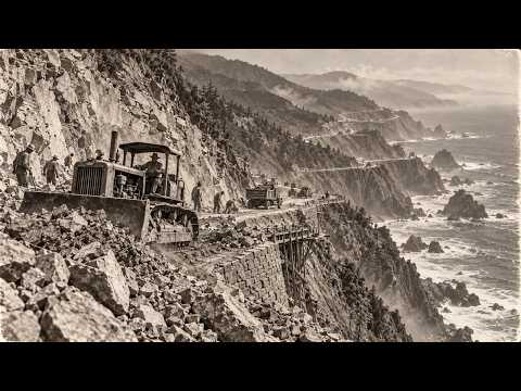
Now the state had money. What it needed was a way to put a road on a cliff that went straight into the surf. Here is how you cut a shelf into a mountain that has no shore. You can’t build up from the beach because there is no beach. So you work from the side. You drill a line of holes into the rock face, pack them with dynamite, and blow a notch out of the slope. Then you stand in that notch and do it again a little farther along and a little deeper, until the notch becomes a ledge wide enough for a truck.
Think of cutting a step into a steep snow bank with a shovel. You don’t carry the snow away. You throw it over the edge and the slope below takes it. On Big Sur, the slope below was the Pacific Ocean. Every shovelful of that mountain went over the side and into the sea.
The first contractors on the job were a firm called Blake and Heene. In 1921, they set up a camp at Piedras Blancas near the southern end of the route for 120 prisoners and 20 paid laborers. It was the first time the state tried that mix of men on this road. It would not be the last.
The north end started too, out of Carmel and down toward the Big Sur River. By October of 1924, two pieces of the road were finished, including about ten miles running south from Big Sur to Anderson Canyon. And then, with the hardest part still ahead of them, the crews looked up and saw what was left.
The finished pieces were the easy ground. Between them lay the heart of the coast, the stretch where the mountains are steepest and the cliffs fall farthest. It was the part Roberts and Powers had walked and photographed, and the part every engineer knew would cost the most.
That was when the second enemy showed up. The bond money was gone. One and a half million had bought two short pieces of road and a lot of rock in the ocean. The federal government had put in money, and in 1921 the voters had approved more state funds on top of the bond. It was still nowhere near enough for what was left.
The man who had sold the road to the legislature wasn’t there to sell it again. Elmer Rigdon died in office on the 13th of December, 1922, before the money ran out and long before the road reached his hometown. By 1926, the work had stopped. Anderson Canyon, which should have been a midpoint, became a dead end. You could drive south from Carmel past Big Sur to the edge of the canyon, and then the road simply ended in brush and rock above the ocean.
For the people living south of that point, nothing had changed. Supplies still came by boat or over the inland trail. A family that broke an axle or needed a doctor was in the same place John Roberts had found it thirty years before.
Meanwhile, on the hill above San Simeon, a newspaper owner named William Randolph Hearst had started building a castle in the same year the road began. His builders could haul marble up a hillside. The state of California could not get a road along the coast below it. The federal highway history notes almost in passing that in the end the castle cost about as much to build as the highway did.
One man was building a palace on a hill. The state was trying to build a shelf along the bottom of it. Both of them were fighting the same Santa Lucia mountains, and only one of them had a budget that never ran out.
The people on the coast noticed. The longer the work sat still, the more the whole project began to look like one of those ideas that gets a bond, a ceremony, and a few miles of grading, and then quietly turns into a dead end on a map.
The stretch nobody had touched was the most dangerous mile after mile of the whole route, and it would stay untouched until the state solved a problem that had nothing to do with rock. It needed men—lots of them, for years, in camps far from any town, doing work most free laborers would not take at any price the state could afford.
In March of 1928, the state found its workforce, and it came from San Quentin.
San Quentin State Prison set up three camps on the Big Sur coast. One went in by the Little Sur River at the north end. One went in at Kirk Creek, far to the south. Later, a third was built at Anderson Creek, right at the edge of the canyon where the old road had died. Each camp was a cluster of rough buildings and tents on whatever flat ground the crews could blast out of the hillside, and the camps moved as the road moved.
The deal was simple, and the state was proud of it. A prisoner who volunteered for the road camps was paid, and his sentence was cut short in return for the work. The federal highway history puts the pay at thirty-five cents a day. That number sounds small, and it was smaller than it sounds.
Out of those cents came deductions. The prisoners paid for their own clothing, their food, their medical care, their toilet articles, their transportation to the camp, and even the construction tools they used. And there was one more line on the ledger. If a man ran, the state paid a $200 reward to whoever caught him, and that $200 was taken automatically out of the convict’s pay.
Think about what that meant on a ledge above the ocean. Every man in the camp was helping to pay the bounty on any man who tried to walk away. The fence around those camps was mostly the mountain and the sea. The money did the rest.
One count of the books after the deductions puts what a man actually kept at about thirty-four cents a day. A free laborer on the coast in those years would have wanted many times that, and he would have gone home at night. The convict stayed on the mountain, and every day he stayed took a day off his sentence. That was the real wage: time.
And still the state got something it could never have bought on the open market. Free laborers had choices. A man with a paycheck and a family in Monterey did not have to hang off a cliff in a winter storm. A man with years left on his sentence had a reason to take that job and keep it.
For the next nine years, those men cut the middle of the coast. The work was the same notch and ledge over and over, but now it ran through the worst rock on the route. Seventy thousand pounds of dynamite went into the granite, marble, and sandstone, and more than ten million cubic yards of rock were blown away.
Almost all of it went the same direction: over the edge and down into the surf. Not every stick of that dynamite went off when it was supposed to. Some of it stayed right where the powder crews had packed it, under the new road, waiting.
Then the convicts came to a place where no amount of dynamite would help. Bixby Creek cuts down to the sea a few miles south of Carmel, and at the crossing the canyon is more than 260 feet deep. You could not blast a ledge across empty air.
In August of 1931, the state opened bids for a single concrete arch. Ward Engineering signed for a little over $23,000, and eleven days later the work started at the bottom of the canyon. But a concrete arch cannot hold itself up until it is finished. So before the bridge could exist, a second structure had to exist beneath it: a wooden tower 250 feet tall, built from more than 300,000 board feet of Douglas fir.
Picture what that looked like from the rim. A forest of bare timber climbing out of a canyon on the edge of the Pacific, taller than a twenty-story building, with men moving along the crossbeams at every level.
They strung cables across the gorge and rode platforms out over the empty air. 825 truckloads came down the half-built road. 600,000 pounds of reinforcing steel. 6,600 cubic yards of concrete mixed from 45,000 sacks of cement.
On the 15th of October, 1932, about fourteen months after the contract was signed, the bridge was finished, under budget, at a little under $200,000. The wooden tower came down. The arch stood on its own, 260 feet above the creek, holding up nothing yet but a stretch of road that still went nowhere at either end.
In 1932, Anderson Canyon, the old dead end, became the largest prison labor camp on the coast. From there the crews worked the last of the wild middle, and wherever a creek came down to the sea, they built another bridge. By the federal count, the highway ended up with thirty-three of them.
On the 27th of June, 1937, Governor Frank Merriam led the dedication ceremonies for the Carmel to San Simeon Highway. Eighteen years after the voters approved the first bond, a car could drive the whole coast without turning inland. The first estimate had been $1.5 million. The final bill was about $10 million.
Elmer Rigdon had been dead for almost fifteen years. At the dedication, his widow planted a silver fir in his memory. The convicts were not at the ceremony. Their camps were folded up. Their work was under the asphalt, and their names are not on any marker I could find.
The road had been open for one winter when the rain came back. The storms of early 1938 buried it in pieces before its first birthday. Crews dug it out. That became the rhythm. Every wet winter, part of the mountain came down onto the shelf, and every spring, someone cleared it and opened the road again.
In 1945, a road crew dug down under the pavement and found sticks of dynamite. They were original—packed into the rock by the powder crews of the twenties and thirties, failed to fire, buried when the grading went over the top. For years, cars had been driving the Big Sur coast over live explosives that nobody knew were there.
Then came the winter of 1983. On the 1st of March, a slide between Rocky Creek and Bixby took out about 200 yards of highway. By the 11th, convoys were being led across the slides, cars crawling in groups with equipment operators standing by to push back whatever the slope sent down next.
Ernest Pierce—Skinner—was one of those operators. On the 1st of April, 1983, he was on a slide working his machine against the mountain. At ten minutes to one in the afternoon, the slope gave way and he went down with it. He did not survive.
Fifty years after the convicts, with real machines and real engineers, the mountain could still take a man off the road in the middle of a working day. And the worst slide of that year had not even finished moving yet.
Near the entrance to Julia Pfeiffer Burns State Park, the whole mountainside let go. The slide was 963 feet high and buried the highway under about four million cubic yards of rock and dirt. Twenty-six bulldozers worked it for twenty-two weeks, pushing the debris off the road and once again over the edge into the Pacific—the same direction the convicts had thrown it. It took fourteen months and around $10 million, about what the entire road had cost to build.
Half a century after it opened, the state paid roughly the price of the whole original highway to get one piece of it back. And the method had barely changed. Push the mountain into the sea and rebuild the shelf.
In 1998, the El Niño storms damaged the highway at about forty different places. The bill came to about $32 million. That winter pushed the state to write a formal plan, because it was obvious the slides were not an accident. They were the coast doing what it had always done. You don’t finish a road on Big Sur. You keep it.
In 2017, the slides went for the bridges. A landslide began moving under the Pfeiffer Canyon Bridge, and one of its support columns fractured. The state demolished it with a six-ton wrecking ball and a hydraulic hammer, nine days of careful work on a slope that was still unstable.
This time the engineers did something new. The old bridge had stood on columns planted in a slope that moved. The new one would have no columns at all—a single span of fifteen steel girders, each weighing sixty-two tons, reaching 310 feet across the canyon from rim to rim. Nothing would touch the moving ground in between. It opened in October of 2017, about eight months after the old one cracked.
Because thirty-six miles to the south, at Mud Creek, the mountain had done the thing everyone on that coast had always feared.
Years later, a team led by Alexander Handwerger at NASA’s Jet Propulsion Laboratory went back through satellite measurements. Mud Creek had been sliding since at least 2009, at about seven inches a year—slow enough to live with. Then came a five-year drought, and the ground dried out and cracked. And the winter of 2017, right after it, was one of the wettest this coast had seen in a century. The rain poured into that parched slope and built up water pressure between the particles of soil, deep down. It is the sand castle again, on a scale of millions of cubic yards.
On the 19th of May, a small slide came down and covered part of the highway. A warning. On the 20th, the crews were pulled off the slope. That same day, the mountain let go.
More than six million cubic yards came down at once. It buried a quarter-mile of Highway 1 in places under dozens of feet of debris, and kept going more than 500 feet past where the beach had been. When it settled, the coast of California had fifteen new acres that had not existed the day before.
Caltrans would later call it a miracle in its own magazine, and for once the word was not an exaggeration. The mountain waited until they were gone.
For about five months, the people living along the middle of Big Sur were nearly as isolated as the families John Roberts used to ride out to. Supplies came in on a narrow back road over the mountains, or not at all. Some merchants saw their revenues fall by as much as ninety percent.
This was the moment the engineers had to answer the question this whole story has been asking. For a hundred years, the answer had been the same: cut into the slope, and when it comes down, push it off the road and cut again. At Mud Creek, that answer was dead.
So Caltrans stopped cutting. The state hired John Madonna Construction on an emergency contract, and instead of digging the old road out, the engineers designed a new one that would run right across the top of the landslide. The mountain had thrown fifteen acres of rock into the ocean; they would build the road on top of what it threw.
They shaped the slide into a new grade and buttressed it with embankments and berms. The real enemy was water, so they built the biggest drainage system that stretch of coast had ever had—a main pipe sixty-three inches across, wide enough for a grown man to walk through, stooped. Along the water’s edge they built a wall of heavy rock to keep the tide from chewing at the toe of the new embankment. The convicts had spent nine years throwing the mountain into the ocean. Now the state was building a barrier to keep the ocean from taking the mountain back.
Nobody worked at night. Nobody worked when the fog came in, because safety spotters had to be able to watch the mountain for falling rock. Every day started and ended with someone looking up.
John Duffy, a geologist and engineer who worked on the plan, put the whole problem in one sentence. He said it is an emerging coastline, geologically speaking, in a constant state of trying to come to some stability. That is the most honest description of Big Sur I have found in any report. The coast is not broken. It is still being made, and the road happens to be sitting in the middle of the construction site.
On the 18th of July, 2018, about fourteen months after the slide, Caltrans opened the new Highway 1 across Mud Creek, roughly two months ahead of schedule, at an estimated $54 million. More than eighty classic and modern cars drove the coast in a celebration that summer. They called it a dream drive from Monterey down to Morro Bay. Most of the people in those cars had no idea that the road under their tires at Mud Creek had been a pile of loose rock in the ocean a year before. That was the whole point. When the job is done right on this coast, nobody can tell it was ever done at all.
And that is the answer to the question this road has been asking since 1897. You don’t beat this mountain. The convicts never beat it, and neither did the bulldozers of 1983. You lean on it the way the Bixby arch leans on its canyon walls. And when it throws a piece of itself into the sea, you build on top of what it threw.
So where can you still see each round of that fight? If you drive the coast today, start at Carmel and head south. A few miles out of town, before you reach the famous bridge, you cross Rocky Creek. This is where the road fell away in 2011. On Easter weekend of 2024, in heavy rain, part of the southbound lane went again—about six feet of pavement and part of an old unreinforced masonry retaining wall dropped 170 feet to the ocean. Around three hundred cars were stuck waiting to head north. Some people slept in them overnight.
A minute later, you are on Bixby Creek Bridge. The arch that was poured onto a wooden tower in 1931 is still carrying the road. Between 1998 and 2000, the state spent about $20 million strengthening it against earthquakes—a hundred times what it cost to build. The mountains on either side have moved. The arch leaning on its rock has not fallen.
Keep going and you pass the mouth of the Little Sur River, where San Quentin put its first camp in 1928. Then Point Sur, the rock where the Los Angeles went aground and where John Roberts rode out on horseback to reach the injured. Pull off and look at the water around that rock. Picture a country doctor on a horse, picking his way along trails behind those ridges, knowing people were hurt on the shore and that there was no faster way to reach them. Everything south of here began with that ride.
Past the village of Big Sur, you cross Pfeiffer Canyon on the steel bridge with no columns, the one built in eight months in 2017 to step over a slope that would not stop moving. At Julia Pfeiffer Burns State Park, look up at the hillside. That is the ground that came down in 1983, the same spring Skinner Pierce died working the slides.
A few miles south is Anderson Canyon. This is where the road dead-ended in the twenties, where the biggest convict camp on the coast stood in the thirties, and where Henry Miller rented one of the old shacks in the forties for five dollars a month. Stand at the edge of it and try to imagine 1926, when the pavement simply stopped here and the rest of the coast to the south was still a week of trails and a boat landing. Every mile you are about to drive was still to come.
Two miles south of the Esalen Institute, you cross Rat Creek. In 2020, the Dolan Fire burned about 128,000 acres of these mountains and stripped the hillsides bare. In January of 2021, an atmospheric river dropped about sixteen inches of rain on the burn scar, and by the next day, 150 feet of Highway 1 was simply gone. Drone footage of the gap went around the world. Crews rebuilt it with oversized culverts and overflow pipes, and it reopened in April for about $11.5 million.
Farther south, about four miles north of Lucia, pull over at the small park with the drinking fountain. That is the Elmer Rigdon Memorial, on the road he argued for and never drove.
Down near Lucia, a slope called Paul’s Slide closed the road and took about $24 million to fix before it reopened in the summer of 2024. Just south of Big Creek is Regent Slide. It came down on the 9th of February, 2024, and closed 6.8 miles of the highway. The road did not reconnect until the 14th of January, 2026, after about $82 million of work—months earlier than the state had promised. For the first time in years, the whole coast was open again.
Past Lucia and Kirk Creek, where the southern convict camp stood. Past Gorda, you reach Mud Creek. You will drive across the new road without feeling anything. Look to your right. The land between the asphalt and the waves is the slide of 2017, fifteen acres of mountain the ocean has not yet taken back.
And at the bottom of the coast near Piedras Blancas is where the first 120 prisoners and 20 paid men made camp in 1921, before the road reaches San Simeon and the castle on the hill. The castle that went up while the road was being cut is still there on its hill above the end of the drive. One of them was finished. The other one never will be.
The drive takes a few hours. In John Roberts’ time, the same trip took days on a wagon road, or most of a week on foot, or it happened by ship. Go back then to the picture. This all started with a thin concrete arch rising out of a forest of timber over Bixby Creek, the Pacific behind it, men walking the planks 250 feet in the air.
That wooden tower was never meant to last. It held the arch only until the arch could hold itself, and then the crews took it down, and nobody saw it again. The whole road has worked that way ever since. Convicts, bulldozer crews, bridge builders, and slope engineers—each one holding up their piece of it for a while, so the road can stand a little longer on a mountain that has never once agreed to keep it.
So here is my question for you: if you drove that coast tomorrow and knew every mile of it had been held up by somebody’s hands, would you still call it a road—or would you call it a promise?
Report this article
Select a reason for reporting: