On November 11, 1926, highway officials stamped Route 66 onto the map—2,448 miles from Chicago to Los Angeles. But the number was just paint on paper. In reality, about 1,600 of those miles were unpaved dirt, and out in the Texas Panhandle, the pavement simply stopped dead in the open prairie. Turning that line into one hard road would take 12 years, eight state highway departments, and most of the Great Depression.
Two stories haunt the paving records. One is a stretch of Texas mud so treacherous that farm families made a side income pulling stranded cars out of it. The other belongs to a New Mexico engineer given 31 winter days to cut a road through a forest. Both reveal what it truly took to build the Mother Road.
Los Angeles, March 4, 1928. 199 runners lined up at the Ascot Speedway for a foot race to New York, following Route 66 as far as Chicago. Among them was Andy Payne, a 20-year-old Cherokee from near Foyil, Oklahoma—a farm town right on the new highway. He entered for the $25,000 prize, hoping to save his father’s debt-ridden farm.
What Payne ran on was not what the map promised. That spring, almost none of Route 66 in Arizona was paved. The runners crossed the Mojave and climbed into the Arizona high country on gravel and graded dirt—the same surface every car and truck used. Newspapers called it the Bunyan Derby. Of the 199 who started, only 55 would finish.
Payne kept going, averaging roughly 6 miles an hour day after day. He came up through New Mexico and across the Texas Panhandle. When the race reached Oklahoma, he led the field into Chelsea, not far from home. The crowds included Governor Henry Johnston and Will Rogers. On May 26, 1928, the survivors ran into Madison Square Garden. Payne won in 573 hours, 4 minutes, and 34 seconds—84 days of running—and the $25,000 went home to Oklahoma.
A farm kid ran more than 3,400 miles to save a farm, and the first part of that run was on a federal highway that was, in long stretches, a dirt road with a number on it. But the road had a problem no prize money could fix: who paid for it.
Route 66 was mostly a federal number assigned to roads the states already had—most in poor condition. The number brought federal aid, but only on a matching basis, meaning each state had to put up its own share. Those first improvements—grading, regrading, and surfacing—cost around $22,000 a mile. Out west, the highway crossed hundreds of miles of ranch country, desert, and mountain in Texas, New Mexico, and Arizona—states with far fewer people to pay the bill.
Until 1933, improving these roads fell almost entirely on the individual states. The better-prepared states moved quickly, while others, Texas among them, struggled just to keep their stretches passable. Route 66 existed the day the official signed off on it. The hard part was paying to grade and pave 1,600 miles of dirt when every state had to find its own share of the money.
Even the number on the map had been a fight. It came out of a telegraph office in Springfield, Missouri, on Friday, April 30, 1926. Cyrus Avery, a Tulsa oilman and road booster, had wanted this road to be Route 60. But Kentucky’s officials wanted that same number. Oklahoma’s chief highway engineer John M. Page noticed that 66 hadn’t been given to any road yet. Avery and Missouri’s chief engineer wired the proposal to Washington that day, and the number stuck. The most famous highway number in America came from an engineer checking which numbers were still free.
The next winter, on February 4, 1927, boosters met in Tulsa and formed the US Highway 66 Association. They gave the road a slogan—The Main Street of America—and started paying for billboards, magazine ads, and brochures. The whole point of that noise was to push the states into paving the road.
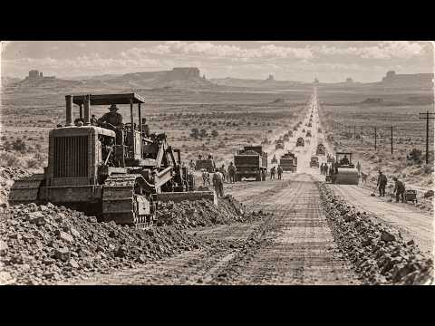
But a number is just paint. What did building Route 66 actually mean on the ground? It meant four jobs over and over, county after county. You graded the roadbed, shaping the dirt into a crown so water would run off—a job that never really ended because after every hard rain, a county crew had to drag the road smooth again. You lined it with ditches and culverts. You bridged the creeks and rivers. And last of all, you put a hard surface on top—gravel at first in the poorer places, then asphalt over a concrete base, or plain concrete poured in long slabs. On old stretches in Texas, you can still see the grooves where one pour met the next.
Some of the road was already there when the number landed on it. In northeastern Oklahoma, the state had graded, drained, and paved the road from Miami to Afton in 1922—a concrete base with a rock asphalt top, 15 and a half miles of it. Around Tulsa that same year, three contractors poured concrete on more than 11 miles. Those names come straight out of the state’s construction chronology.
The best way I can describe what Route 66 really was in its first years is a chain with eight links, each link being forged by a different blacksmith, paying for his own iron, working at his own speed. The chain was only as good as its unfinished links, and some of those links were still long stretches of dirt.
Three years in, somebody finally counted. A Texaco road report from 1929 found that Kansas had its whole stretch in concrete. Illinois was boasting that all of its Route 66 was paved. Missouri was two-thirds of the way there—yes, the real figure was 66%. Oklahoma was about a quarter improved. But the report didn’t stop there. It got to the west: from the Texas line to California, the highway ran about 1,200 miles, and along all of that, there were only about 64 miles of pavement.
Put simply, out west, if you drove Route 66 in 1929, you got roughly one paved mile for every 19 miles of dirt and gravel. And some of the worst of that dirt was in the farm country of the Texas Panhandle, where the trouble was the ground itself.
Texas had its own reason to be slow. Route 66 only crossed the Panhandle, far from the big cities. In 1926, the largest cities in Texas were San Antonio, Houston, and Dallas—none of them anywhere near this highway. As recently as the 2000s, the whole Panhandle, Amarillo included, had around a third of the people of Austin. So Texas was being asked to pay for a highway across a thinly settled corner of the state, a long way from most of the people paying for it.
Between the towns of Alan Reed and Groom, the highway crossed a belt of black soil that people there called gumbo. Dry, it made a decent road. Wet, it turned into a sticky, heavy, waxy goo that stuck to everything it touched and built up on the wheels until a car stopped under the weight of its own tires. That stretch ran about 18 miles, and it took its name from a little settlement along it called Jericho. Travelers called it the Jericho Gap.
The farmers who worked that land knew the gumbo. They wrapped chains around their wheels and got through. Travelers passing through didn’t have chains, and when they bogged down, families along the gap came out with teams of horses and mules and pulled them free for a price. Pulling cars out of the gap turned into steady side income.
There’s a story told about the gap for generations, and I’ll give it to you as exactly what it is—a rumor nobody ever proved. People said some farmers would go out at night with water tanks on wheels and wet down the ruts, so there’d be plenty of customers stuck in the morning. Nobody was ever caught doing it. But people like to point out that plenty of farms along the gap seemed to own one of those water tanks.
Jericho itself was never big. At its height in the 1930s, about 100 people lived there with three stores, a grain elevator, a tourist court, a garage, and a filling station—all of it living off a road that trapped people. And while the gap held on, the pavement kept closing in around it.
On January 5, 1931, Missouri finished paving its stretch, the third state to do it after Illinois and Kansas. By that year, nearly half of the whole highway had a hard surface. In Beckham County, the last Oklahoma county before the Texas line, crews had been pouring concrete between Sayre, Elk City, and Erick since the middle of the ’20s. They’d carried the highway over the North Fork of the Red River on a timber trestle more than half a mile long. Oklahoma was paving right up to the Texas line.
In October of 1932, a newspaper account described the gap as 16 miles long and the only unpaved stretch left on the highway between Amarillo and Oklahoma City—well over 200 miles of new pavement on both sides. And one black hole between them that could hold a car like glue. The association was selling this road as the Main Street of America, and 16 miles of that Main Street could stop a car cold after one good rain.
On July 19, 1934, the state opened bids to pave the Jericho Gap. And what the highway engineers finally did about the gumbo was, I think, the smartest move anyone made on this whole road.
They didn’t pave the gumbo. They moved the highway. When the paved road finally came through, it didn’t follow the old ruts past Jericho at all. The highway department shifted the line about a mile to the north onto higher ground and a straighter path, and put the pavement down there. That fall, in 1936, the new paved road opened, and the Jericho Gap was left behind in the fields. After years of fighting that black soil, the fix was to go around it. Now you could drive from Amarillo to Oklahoma City without ever leaving pavement.
The gap was gone, but it wasn’t the last dirt left in the Panhandle. That piece was farther west. Jericho paid for that. With the traffic gone a mile north, the little town started to empty out. By 1939, its population had fallen to about 50 people—half of what it had been. The families who’d made money pulling cars out of the mud lost that income along with the traffic.
Moving a road was one way to beat a problem, but back in northeastern Oklahoma, years earlier, the state had beaten a different problem—a shortage of money—with a trick drivers can still use today. Remember that early stretch between Miami and Afton? When Oklahoma paved it in the early ’20s, the new surface was only 9 feet wide. That’s one lane for a road carrying traffic in both directions. The pavement ran in long straight pieces joined by six sharp 90-degree turns. Asphalt on top with concrete along the edges. People call it the Ribbon Road or the Sidewalk Highway, and there’s a historical marker for it now.
The story people in Miami tell is simple. The money on hand was only enough to pave that road at full width for about half the distance to Afton. So they paved a narrow road the whole way instead. And drivers made it work. Traffic was light, so you drove right up the center of the pavement. When another car came at you, both drivers eased over until their outside wheels were down in the dirt, passed each other with the inside wheels still on the concrete edge, and pulled back onto the middle once they’d cleared. I love that, honestly. It’s a road built by people who couldn’t afford what they wanted, and who decided a narrow hard road beat a wide muddy one—and they were right.
Route 66 ran over that narrow strip for over a decade, until 1937, when the highway was moved off it onto a newer line. The old road was put on the National Register of Historic Places in 1994, and it’s now the earliest surviving one-lane section of Route 66.
Illinois tried something different on one stretch. South of Springfield, between the towns of Chatham and Auburn, part of the highway was laid in brick sometime between 1926 and 1930. But paving only solves the ground under the road. The highway also had to cross rivers, and the biggest of them came early at St. Louis.
North of the city, the Mississippi runs over a line of rock ledges called the Chain of Rocks—a stretch so rough that it was dangerous to take a boat through. In 1929, a toll bridge built with private money opened across the river right there, just over a mile of steel, and only 24 feet wide. And halfway across, above the river, the bridge turns. It bends 22 degrees out there. From above, it looks like somebody bumped the drawing board, but the bend was deliberate. A water intake blocked a straight crossing, and parts of the bedrock under the river couldn’t hold up piers where a straight bridge would have put them. So the engineers bent the bridge to fit the river bottom, and its longest single span reaches 700 feet. That bend is one of my favorite details on this whole road.
In the late 1930s, a bypass route of Route 66 was laid across that bridge to carry traffic around the north and west side of St. Louis. Cars used it until February 25, 1970, when it closed. In 1998, it opened again, this time for people on foot and on bicycles, bend and all. So the Mississippi got a bridge with a bend in it. The next state over got a rainbow.
Past Missouri, the highway cuts across the southeast corner of Kansas, and that’s the shortest piece of the whole road—only about 13 miles through Galena, Riverton, and Baxter Springs. Between Riverton and Baxter Springs, the road crossed Brush Creek on a bridge that was already there, built in 1923, before the number existed. It’s a single concrete arch of the kind engineers called a Marsh Arch, with the curved concrete ribs rising above the roadway on both sides, and that curve is why everybody calls it the Rainbow Bridge. Route 66 traffic used it until 1960. There were once other bridges of that type along this highway. The one over Brush Creek is the only one still standing.
Down in Oklahoma, the South Canadian River got something even stranger. West of Oklahoma City, near the town of Bridgeport where Canadian and Caddo counties meet, the highway ran into the South Canadian River and its wide bed of sand. In 1933, a new bridge went across it, and it was built in a way that sounds almost stubborn when you hear it. Instead of a few giant spans, the builders crossed the river with 38 separate steel trusses set end to end. Each one was 100 feet long. They’re pony trusses—the low kind with no bracing overhead. So from the driver’s seat, you see open sky above you the whole way across. Put together, the bridge ran 3,945 feet, about three-quarters of a mile of steel over sand. It still counted as the longest known simple span pony truss bridge in America. People along the highway just called it the Pony Bridge, though its official name is the William H. Murray Bridge. After a four-year rebuild, it reopened to traffic in May of 2024, and it’s still carrying cars over the South Canadian.
So Oklahoma had narrowed its pavement to stretch its money and strung steel across a river to get its traffic over the sand. But the hardest climb on the entire route was a mountain pass in western Arizona where some drivers had to take the grade backward.
West of Kingman, the original highway climbed into the Black Mountains toward the old gold mining town of Oatman. The summit of that climb is Sitgreaves Pass, 3,550 feet up, more than half a mile above sea level, reached by a narrow road of hairpin curves with long drops off the side. The trouble was the cars. A lot of early automobiles had no fuel pump. The gas just ran downhill from the tank into the engine. On a grade that steep pointed uphill, the fuel couldn’t reach the carburetor and the engine would starve and quit halfway up the mountain. So drivers did the one thing that kept the tank above the engine. They turned around and backed up the pass in reverse gear. The stories that come off that mountain say you’d see cars crawling up Sitgreaves Pass rear end first.
On the climb up from Kingman, there was a stop called Cool Springs—a cafe and a filling station on the side of the mountain. In the ’30s, a man named James Walker moved his family out from Huntington, Indiana, to run it. And places like that lived on the cars that were about to try the pass. Not everybody had the nerve for it. Some travelers paid a local to drive their car over the top for them. Others hired a team of horses to haul their car to the summit. And later on, tow trucks worked that grade and made a business of pulling stranded motorists over the pass.
Arizona’s share of the paving count shows how slowly all of this went. In 1928, almost none of Route 66 there was paved. Paving started between Topock on the Colorado River and Kingman the following year. The road from Flagstaff to Winslow was finished in 1931, and the stretch from Crookton to Ash Fork came the year after. Ash Fork had already made a small piece of road history, too. Back in 1921, a short section outside that town became the first road ever paved using volcanic cinders. By 1935, almost all of the highway between Topock and Peach Springs was paved, and that meant the hairpins over Sitgreaves Pass were paved. The cars still had to climb it, but now they climbed on pavement. That mountain line stayed the main road until the early 1950s, when a gentler route through Yucca finally replaced it.
Meanwhile, the far end of the highway actually got longer. In June of 1935, the western end of Route 66 was carried past downtown Los Angeles out to Santa Monica. So the road now finished right at the ocean. But long before that, every state along the highway had run into a bigger problem than any mountain. The money was drying up.
The crash came late in 1929, and over the next few years the Depression drained the states of the tax money they’d been using to match federal road funds. For a highway that was being paved one state share at a time, that was close to a death sentence. For the unfinished miles, most of the eastern states had finished before the money went, and most of the unfinished miles were out west. That timing decided which families would end up driving the worst of the road. And the strange part is that the road was getting busier the whole time.
Trucking had grown so fast that by 1930 it rivaled the railroad for shipping freight. And Route 66, running across flat prairie and warm desert, was exactly the kind of road truckers wanted. Between Chicago and St. Louis, about 1,500 trucks a day were using the highway in 1931. One in four of them was a big tractor pulling a semi-trailer. That was the squeeze the western states were stuck in. The highway engineers knew what they wanted this road to become. The goal was a modern all-weather highway with fewer curves, wider lanes, and a surface the maintenance crews could keep open in any season. So you had more weight on the road every year, a clear idea of what it should be, and less money to pave it.
Then the weather turned on the people living along it. Through the early 1930s, drought and wind stripped the topsoil off the southern plains. Dust storms rolled across Kansas, Oklahoma, the Texas Panhandle, and eastern New Mexico. Some of them dark enough that people called them black blizzards. Farms that were already struggling went under. And the families who left went west on Route 66. By one estimate, about 210,000 people migrated along this highway to California to get away from the Dust Bowl.
And look at the road those families were driving on. The eastern half of the road through Illinois and Missouri and most of Oklahoma was paved by then. But the western half through the Panhandle and New Mexico and Arizona still had long stretches of gravel and graded dirt and the Arizona mountain grades and the Jericho Gap. A lot of those overloaded cars and trucks crossed the unfinished part of the road with everything the family owned tied on top. And most of them didn’t stay. The National Park Service’s study of the road found that barely 8% of the Dust Bowl migrants who set out for California remained there. Fewer than 16,000 of the people from the Dust Bowl proper stayed on. The rest moved on or went back the way they’d come.
For a lot of those families, the highway stood for what the Texas survey calls the road to opportunity. In 1939, John Steinbeck put families like that into The Grapes of Wrath and gave this highway the name it still carries. He called it the Mother Road, the road of flight. The number about who stayed is the one that stopped me cold. We tend to remember this highway the way Steinbeck wrote it, as a one-way road out. By the Park Service’s numbers, more than nine in 10 of those families didn’t stay in California, and a lot of their miles were on dirt that nobody had yet found the money to pave.
That same traffic kept roadside businesses going along the whole route—the filling stations, the cafes, and the tourist courts—even in the worst years. Meanwhile, the people who never left were trying to get by in the ruined economies of Kansas, Oklahoma, West Texas, and New Mexico. And the road itself was one of the places they could still find paid work. So this is where Route 66 stood in the spring of 1933. The busy eastern end was paved while the western end still had long stretches of dirt. The states that owned those miles were broke, and the people living beside them needed work badly. The answer came out of Washington that June, and it came with a rule the states had never been offered before.
On June 16, 1933, the National Industrial Recovery Act became law. Inside it, as part of more than $3 billion for public works, was $400 million in grants to the states for building roads. And unlike the federal road money that came before it, this money came with no matching requirement. A state with an empty treasury could take it and pave. The act did something else that mattered to a road like this. Federal road money could now be spent inside cities and towns, which it never could before, on the streets that carried a federal highway through them. And Route 66 was the main road through hundreds of towns.
The act had a second rule, and it was about the men. Workers on those projects were limited to 30 hours a week at what the law called just and reasonable wages. With the week kept that short, the same mile of road took more men to finish. And in 1933, plenty of men needed that work. From 1933 to 1938, thousands of unemployed men, a lot of them young, from nearly every state in the country, worked as laborers on road gangs along this highway. The Civilian Conservation Corps and the Works Progress Administration made road improvement and maintenance part of their jobs. The Texas Preservation Survey gives that relief work the credit for closing the gaps that were left.
There’s one line in the National Park Service’s study of Route 66 that surprised me more than anything else in these records. It says the highway affected more Americans on federal work relief than people who used it during the famous exodus to California. So the famous photographs mostly show the smaller crowd. The bigger crowd was down in the ditch beside the road holding a shovel.
And a lot of what those crews built was the stuff nobody photographs. In Texas, much of the relief work across the state went into culverts—the small structures that carry water under a road. Crews from the Works Progress Administration, the Civilian Conservation Corps, and the National Youth Administration built them with masonry wing walls and headwalls. Stone set by hand, work that needed skilled masons and plain laborers side by side. It was slow, heavy, careful work. It was so labor-hungry, in fact, that once the Depression ended, the Texas Highway Department mostly stopped building culverts that way and switched to cheaper concrete pipe and box designs. So a stone culvert under an old Texas highway is very often a piece of Depression relief work set by men working their 30-hour weeks.
Money and men could finish a road. But out in New Mexico, the line those relief crews would end up paving had been cut years earlier by one engineer’s crews in a single winter month.
New Mexico, November of 1926. Governor Arthur T. Hannett had just lost his race for re-election, and he had until New Year’s Day before he left office. Route 66 in New Mexico took a long, winding loop north to Santa Fe, the capital. Hannett wanted a straight road instead, running west from Santa Rosa through Moriarty to Albuquerque and cutting Santa Fe out of the route entirely. He gave the job to E. B. Bale, the state highway engineer, and Bale had a deadline problem. He had about a month before a new administration took over, and not one mile of the new line existed yet.
Bale split his men into two crews. He took one himself and worked east from Moriarty. The other, under Sam Fulton, worked west from Santa Rosa. And the idea was that the two would meet somewhere out on the high plains between them. The machines were whatever the state could scrape together—a makeshift collection of tractors and graders and surplus caterpillar tractors left over from the First World War. Old machines that had already been used hard before they ever reached New Mexico. And they had a forest in the way. Near Moriarty, Bale’s crew had nearly 30 miles of piñon to get through. There was no time to cut the trees one at a time, so they chained them to the tractors and pulled them out mile after mile and graded the roadbed right behind them. They moved like men on a deadline because they were.
The crews cut through ranch fences without waiting for condemnation papers. Not everyone along the line wanted that road, either. Some people poured sugar into the gas tanks of the machines and threw sand into the engines to slow the work down. It was December on the high plains of New Mexico, bitterly cold, and the crews kept grading. On New Year’s Day, 1927, the incoming administration sent its own engineer out to a spot called Palma, about halfway between the two crews, with orders to shut the work down. But the weather took a side. A heavy snowstorm blew in, and the engineer couldn’t reach the crews until January 3rd. By then, the two crews had met. They’d surveyed, cut, scraped, and graded 69 miles of new highway. It had taken them 31 days.
69 miles through a piñon forest in a New Mexico December with worn-out war surplus tractors and sugar in the gas tanks. Nothing else in the paving records of this highway moves that fast, and it wasn’t even paved—just graded dirt. And for the next 10 years, that dirt shortcut wasn’t officially Route 66 at all. The road was there, but the highway on the map still made its long loop north through Santa Fe.
What finally changed that is where the paving race comes down to its last miles. September 26, 1937. Eleven years after the number went on the map, Bale’s old shortcut became the official line of Route 66. From Santa Rosa, the highway now ran straight west through Moriarty to Albuquerque, and Santa Fe dropped off the route. The old New Mexico stretch had wound across 506 miles. The new line did the same job in 399. That’s a 107-mile cut out of the highway in a single state. And the line that cut them had been graded by two crews in one winter month a decade before. This time it came with pavement. As the new line was made official, it was paved, and before 1937 was out, Route 66 in New Mexico was paved from one state line to the other. No highway in New Mexico had ever been paved all the way across before.
West of Albuquerque, the new line crossed the Rio Puerco on a steel truss bridge that had gone up in 1933. It’s a Parker through truss, the kind where the road runs inside the steel framework, and the truss rises in a hump over the center of the span. It had been waiting on that line for four years. Meanwhile, Arizona was closing out its own last gaps. By 1938, every mile of Route 66 in Arizona was paved, and it was one of the first highways in that state paved from end to end.
So in the first half of 1938, the count that had started with about 800 paved miles back in 1926 came down to one last piece of unpaved highway. You’ll often hear that the Jericho Gap was the last dirt on Route 66. By then, the new paved road had been running past the gap for almost two years. That last piece was back in the Texas Panhandle, all right, but out at its western edge in Oldham County. The last unpaved section of the whole highway ran between the little town of Adrian and Glenrio, right on the New Mexico line. Texas had been one of the last states to finish its stretch, and this was the last piece of it.
By mid-1938, the paving crews had covered that stretch, too, and the finish was marked with a celebration right there in Oldham County. I’d give a lot to know who was on that last crew. None of the records I found named them. Then there’s Adrian itself. There’s a sign in that town today saying it’s 1,139 miles to Chicago. The same sign says it’s the same distance to Los Angeles. Adrian is the midpoint of Route 66. So after a dozen years of paving, the very last dirt on the whole highway lay just west of its halfway point. The eastern states had finished years before, and the west had come in last. So the final gap closed almost exactly at the road’s halfway mark. It’s almost too neat. You couldn’t write it more tidily if you tried, and nobody designed it to end there. That’s just how the paving happened to finish.
That year, the Chicago to Los Angeles Highway was reported as continuously paved. Now a family could leave Chicago and roll to the ocean at Santa Monica without their tires touching dirt. Ten years earlier, Payne had run across the west on dirt. A runner could have gone every mile from the Pacific to Chicago on pavement. The US Highway 66 Association, the group that had been printing brochures since the winter of 1927, finally had the road its slogan promised.
But a road finished in 1938 was finished for the traffic of 1938, and that traffic didn’t stay the same size. Between Chicago and St. Louis, trucks on the highway reached about 7,500 a day by the early ’40s. That was five times the truck traffic of 1931. The army had been marking roads like this one as important to national defense since 1922 on what was called the Pershing Map. And in 1939, with war spreading in Europe, the War Department ordered the Public Roads Administration to survey the nation’s key highways. The surveys found that many federally funded roads were already in poor condition and many of their bridges couldn’t safely carry military trucks. The road that had just been finished was already being measured against loads nobody had planned for in 1926, and the west was exactly where the army wanted to train. It was isolated, it had a mild climate, and military bases went up near Route 66 in Missouri, New Mexico, Arizona, and California. In Arizona alone, the military investment ran to over $230 million.
Meanwhile, the car factories went to war work. American plants built 3.7 million cars in 1941, and in 1943, they built 610. That’s the part of the story where Route 66 starts getting widened, rebuilt, and rerouted, and eventually replaced by the Interstate, which is a whole story of its own. But the pavement those crews laid down between 1926 and 1938 didn’t all disappear. A surprising amount of that pavement survives, and most of the route can still be driven.
Start in downtown Chicago and head southwest across the Illinois prairie, through Joliet and Pontiac and Bloomington to Springfield, the state capital. By 1929, Illinois had about 7,500 miles of paved road, and its whole piece of Route 66 was part of that. Just south of Springfield, between Chatham and Auburn, look for the brick. Then the road runs on through Litchfield and Edwardsville toward the Mississippi. At St. Louis, you can leave the car, walk out onto the Chain of Rocks Bridge, and stand right at the bend.
Across Missouri, the old road winds through the Ozarks, through Rolla and Lebanon to Springfield, Missouri, and on west through Carthage and Joplin. Then comes the short run across the corner of Kansas, all of it in Cherokee County, through Galena and Riverton, over the Rainbow Bridge on Brush Creek, and into Baxter Springs. The Rainbow Bridge went on the National Register in March of 1983, and it was restored about a decade later.
In Oklahoma, the first thing to find is the Ribbon Road south of Miami, that 9-foot strip of old pavement between the fields toward Afton. It’s worn now, and the Oklahoma Route 66 Association has been running a campaign to save it before it breaks up for good. Drive it slowly, and if somebody comes the other way, you’ll find out the old passing rule still works. The state’s chronology even lists a gravel stretch past Afton, just over two miles graded, drained, and surfaced in 1921. Past Vinita comes Foyil, where a bronze statue of Payne stands beside the highway he ran. If someone in your family ran a grader or poured concrete for an Oklahoma paving outfit in those years, the Oklahoma Department of Transportation has published a chronology of every Route 66 construction project in the state, county by county, with the contractors’ names, along with a gallery of photographs from those years.
Then Tulsa, Avery’s town. He’d come to Oklahoma Territory as a young man in 1901, and he sat on the Tulsa County Commission in the 1910s, years before anyone asked him to help number a national highway. Avery lived until 1963, and he died in California, the state at the far end of his road. After Tulsa, it’s Sapulpa, Stroud, Chandler, and Oklahoma City, where the state’s chronology starts with its oldest project on this route. It’s from 1919, a bit over half a mile of pavement on 23rd Street near the state capital, laid by the Western Paving Company and M. A. Swatek, seven years before there was any Route 66. West of the city you reach El Reno, and then the Pony Bridge at Bridgeport. All 38 trusses still carrying cars across the sand after more than 90 years. After that, it’s Weatherford, Clinton, Elk City, Sayre, and Erick, the Beckham County concrete, and the Texas line.
Texas is where the road still shows its seams. Texas finished last, but its piece of the highway had been carrying everything from the start—farm trucks, cross-country freight, the Dust Bowl families, and later the military. In 1931, the Auto Club guide measured Route 66 in Texas at a little under 195 miles. When the Texas Historical Commission surveyed the old route, it found that about 91% of the original Route 66 in Texas can still be driven, mostly as frontage roads, business routes, through towns, and county farm roads. The drivable mileage keeps shrinking, though. The Park Service counted at least 185 drivable miles in Texas in 1994. And by 2002, it was about 178.
At Shamrock, you’re in the Panhandle. Just west of McLean, there’s a stretch of abandoned old pavement that the survey singled out as one of the few pieces in Texas with its historic character still intact. Past Alan Reed, out in the fields on private land, is what’s left of the Jericho Gap. When the state surveyed it, that land belonged to Delbert True. Near it are the remains of Jericho’s Tourist Court, which went up around 1910, long before anyone had heard of Route 66. Then Groom, and just east of Conway, another stretch the survey marked as intact. Out of all the old road in Texas, the survey recommended only three locations for the National Register, and that stretch leading into Conway was one of them.
Through Amarillo, the road runs as a city street now, but on West 6th, under the old Rock Island Railroad underpass, just east of Bowie Street, there’s a section of the original roadbed. And you can still see the pour marks from the concrete crews—a seam where one pour ended and the next one began. West of town toward Vega, the very first alignment is still there if you know how to look for it. A faint cut in the ground just north of the Interstate frontage road. Then Adrian and its midpoint sign, out in Oldham County, alongside the railroad tracks. The survey also found old unpaved segments of the road that nobody has fully explored. All along the Texas route, it documented old bridges and culverts still sitting in place beside the road.
After Adrian comes Glenrio. It’s nearly empty now, a ghost town, but the survey found the old road through it remarkably intact. Glenrio even has the only stretch of old Route 66 in Texas laid out as two lanes with a median down the middle. If you stand in Glenrio and look east toward Adrian, you’re looking at the last stretch of Route 66 anyone ever had to pave. Of every stop on this road, that’s the one I’d most want to stand at, because nothing there looks important, and it’s where the whole 12-year job ended.
In New Mexico, it’s Tucumcari and Santa Rosa and then a fork in the road’s own history. Turn north on the old loop toward Santa Fe and you’re driving the road of 1926. Keep straight west through Moriarty and you’re on Bale’s line, the one those crews graded through the piñon in a single December. Moriarty is where Bale’s own crew began working east into the trees. Santa Rosa is where Fulton’s crew started west, and I’d bet very few of the people driving that stretch today know it was built as a race against a deadline. Past Albuquerque comes the Rio Puerco bridge and then Grants and Gallup and the Arizona line.
In Arizona, it’s Holbrook, Winslow, and Flagstaff, then Ash Fork, then Williams. Williams was the very last town on the whole route to be bypassed by the Interstate on October 13, 1984. Less than a year later, on June 26, 1985, Route 66 was officially decertified and the familiar highway signs came down. The association that had spent all those years pushing for pavement had already changed its name in 1970 to the Main Street of America Association, and it disbanded in November of 1979.
West of Williams, it’s Seligman, Peach Springs, and Kingman, and then the old road up past Cool Springs to Sitgreaves Pass. Cool Springs burned to the ground in 1966, and it was rebuilt and restored in 2004. So the old stop stands on that climb again. A little farther along are the remains of Ed’s Camp, the trading post Ed Edgerton built after he came out to those mountains as a miner in 1917. Those hairpins are still open, and this time you can take them facing forward and wind down the other side into Oatman and out to Topock on the Colorado River.
Across the river it’s California. Needles, then the long desert run through Amboy, which went nearly silent once the traffic left, and on to Barstow, down through San Bernardino and across Los Angeles to Santa Monica, where the road runs out of land at the Pacific.
That spot east of Groom, where hard road gave way to Panhandle gumbo, was only one edge of many, and none of them stayed put. County crews and state contractors pushed those edges forward through the ’20s, and relief gangs pushed them through the ’30s. Out in New Mexico, two crews racing a governor’s last month cut a line that would later shorten the road by over 100 miles. For 12 years those edges moved state by state, one pour at a time, until the last of them closed out in Oldham County just west of the exact middle of the road.
That’s how America built it. Eight states and dozens of counties each paying for their own piece, a mile at a time, until the pieces touched. 100 years after the line went on the map, that’s what Route 66 really is—the place where all those edges finally met. The road that finally replaced it is the next story: how America cut 41,000 miles of Interstate across the country.
So what do you think? If you could stand at one spot on the old road—Glenrio, the Jericho Gap, Sitgreaves Pass, or the Chain of Rocks Bridge—where would you go, and why? Let me know in the comments below.
Report this article
Select a reason for reporting: