In 2009, David Bustos, the resources manager at White Sands National Park in southern New Mexico, noticed human footprints preserved in the mud of an ancient dry lake bed. The impressions showed clear anatomical details: heels, arches, and toes. The discovery set in motion a scientific investigation that would eventually challenge long-held assumptions about when humans first arrived in the Americas.
For decades, park staff had occasionally seen faint impressions in the white gypsum mud of the Tularosa Basin. They called them ghost tracks and generally assumed they were left by animals or modern hikers. The footprints Bustos found were different, and over the next ten years, he and his colleagues quietly documented the trackways across the park. The preserved layers extended for miles, with modern estimates suggesting the site contains hundreds of thousands of tracks.
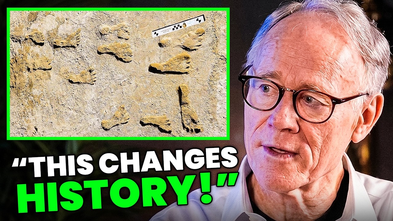
In 2019, Bustos brought in Matthew Bennett, a professor at Bournemouth University who specializes in fossil footprints. Bennett’s team focused on a single excavation site called Locality 2, where footprints were found in seven distinct sediment layers. They identified 61 footprints with good anatomical definition. The majority of them were left by children and teenagers.
The age of a footprint cannot be measured directly. It must be inferred from the surrounding material. At Locality 2, the footprints were sealed in layers containing seeds from Ruppia cirrhosa, an aquatic plant that grew in the shallow brackish water of the lake. The team collected seeds from above and below each footprint horizon and ran radiocarbon dating. The results were internally consistent and held strict stratigraphic order, dating the footprint layers to between 21,130 and 22,870 years before present.
The findings were published in the journal Science on September 24, 2021. They suggested that humans were present in the interior of North America during the last glacial maximum, when large ice sheets still covered most of Canada. The traditional model, known as Clovis First, held that the first Americans arrived around 13,000 years ago. White Sands pushed that date back by nearly 10,000 years, to a time when the ice-free corridor that the Clovis model depended on did not exist.
The paper drew immediate criticism from several prominent archaeologists. One critique centered on the hard water effect. Because Ruppia cirrhosa is an aquatic plant, it absorbs dissolved carbon from water flowing through limestone and carbonate-rich aquifers. That carbon is already old when the plant takes it up, which can make radiocarbon dates appear older than they really are. One team, led by geoarchaeologist David Madsen, collected living Ruppia from the Tularosa Basin and ran it through the same dating process. The living plant appeared to have died 7,400 years ago. Madsen argued that this offset should be subtracted from the White Sands dates, which would bring the footprints to roughly 13,500 to 15,500 years old, still old but no longer a challenge to the Clovis framework.
A second critique, from C. Vance Haynes Jr., proposed what became known as the seed ball model. Haynes argued that seeds can be picked up by wind or shifting lake beds and redeposited on younger surfaces. Under this interpretation, the Ruppia seeds could be genuinely ancient while the footprints they bracketed were pressed into much younger layers by Clovis-era humans around 13,000 years ago.
In response, Bennett and his colleagues returned to the field to find evidence that did not rely on Ruppia seeds. They isolated approximately 75,000 individual pollen grains from the same sediment layers that bracketed the footprints. The pollen came from conifers: pine, spruce, and fir. Unlike aquatic plants, conifers absorb atmospheric carbon dioxide and are not subject to the hard water effect. The team published these results in Science in October 2023. The pollen dates came back at 22,600 to 23,400 years before present, statistically indistinguishable from the original seed dates.
The team also applied optically stimulated luminescence dating to quartz grains in the sediment. This method measures the luminescence signal that accumulates in buried grains from background radiation, which is reset when the grain is last exposed to light. Samples from just below the lowest footprint horizon returned a minimum age of 21,500 years. Three different materials, using three different dating methods, all converged on the same time window.
In June 2025, a fourth independent study led by Vance Holliday at the University of Arizona radiocarbon dated organic-rich wetland sediment from the same time period. Two independent laboratories produced 26 new samples, bringing the total number of consistent radiocarbon dates for the site to 55. The mud ages returned 20,700 to 22,400 years. Holliday described the record as remarkably consistent.
The footprints themselves preserve something unusual for archaeology. Most sites yield objects: stone tools, bone fragments, pottery shards. Footprints preserve actions. At White Sands, they preserve the movements of a community. Children are visible performing tasks, fetching water, and carrying loads. Adults and teenagers moved through the same spaces across generations.
One trackway, described in a separate 2020 paper, runs for more than a mile and a half, then turns and runs back. The prints belong to an adolescent or small adult. The spacing is uneven, suggesting the person was carrying something heavy. Periodically, smaller tracks appear alongside the larger prints: a toddler’s footprints, pressed into the mud for a few steps before disappearing as the child was picked up again. On the outbound journey, the toddler was being carried. On the return journey, the toddler is not present.
At one point, a Colombian mammoth crossed the path of this person. The mammoth’s tracks show no change in direction or speed, no signs of alarm. The animal simply walked past. Elsewhere at the site, a giant ground sloth’s tracks show a different response: the animal rises onto its hind legs, a defensive posture, apparently reacting to something it did not recognize. Human footprints follow the same path. The layers also preserve tracks from American lions and dire wolves.
The people who left these footprints lived in a landscape that no longer exists. The Tularosa Basin was a high-altitude wetland oasis at the height of the ice age, and humans were one species among many. The dates also have implications for how humans first reached the Americas. At 23,000 years ago, the ice sheets covering Canada were fully merged, with no land route through. The people who left footprints in southern New Mexico must have arrived before the ice sheets closed, or they came by a coastal route along the Pacific.
The White Sands evidence does not prove that every disputed pre-Clovis site is correct. But it establishes, beyond serious scientific challenge, that people were present in the Americas thousands of years earlier than the standard timeline once allowed. Other sites that had long been dismissed, including Bluefish Caves in Canada, Meadowcroft Rockshelter in Pennsylvania, and Cooper’s Ferry in Idaho, now appear more plausible in light of the White Sands findings.






